


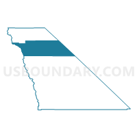
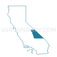
Voting District 40065, Inyo County, California
About
Outline

Summary
| Unique Area Identifier | 531135 |
| Name | Voting District 40065 |
| County | Inyo County |
| State | California |
| Area (square miles) | 1,359.11 |
| Land Area (square miles) | 1,352.37 |
| Water Area (square miles) | 6.74 |
| % of Land Area | 99.50 |
| % of Water Area | 0.50 |
| Latitude of the Internal Point | 37.05044800 |
| Longtitude of the Internal Point | -117.68388200 |
Maps

Graphs
Select a template below for downloading or customizing gragh for Voting District 40065, Inyo County, California


Neighbors
Neighoring Voting District (by Name) Neighboring Voting District on the Map
- Voting District 10000, Inyo County, CA
- Voting District 20040, Inyo County, CA
- Voting District 40055, Inyo County, CA
- Voting District 40060, Inyo County, CA
- Voting District 40066, Inyo County, CA
- Voting District 40080, Inyo County, CA
- Voting District 54515, Fresno County, CA
- Voting District 54545, Fresno County, CA
- BEATTY PRECINCT 01, Nye County, NV
- ESMERALDA GOLD POINT/LIDA PRECINCT 4, Esmeralda County, NV
Top 10 Neighboring County Subdivision (by Population) Neighboring County Subdivision on the Map
- Sierra CCD, Fresno County, CA (18,981)
- Bishop CCD, Inyo County, CA (12,600)
- Independence CCD, Inyo County, CA (2,568)
- Beatty CCD, Nye County, NV (1,032)
- Death Valley CCD, Inyo County, CA (765)
- Goldfield CCD, Esmeralda County, NV (307)
Top 10 Neighboring Place (by Population) Neighboring Place on the Map
Top 10 Neighboring Elementary School District (by Population) Neighboring Elementary School District on the Map
- Bishop Union Elementary School District, CA (11,908)
- Pine Ridge Elementary School District, CA (855)
Top 10 Neighboring Secondary School District (by Population) Neighboring Secondary School District on the Map
Top 10 Neighboring Unified School District (by Population) Neighboring Unified School District on the Map
- Nye County School District, NV (43,946)
- Sierra Unified School District, CA (9,980)
- Big Pine Unified School District, CA (1,860)
- Esmeralda County School District, NV (783)
- Owens Valley Unified School District, CA (677)
Top 10 Neighboring State Legislative District Lower Chamber (by Population) Neighboring State Legislative District Lower Chamber on the Map
- Assembly District 29, CA (510,976)
- Assembly District 34, CA (487,193)
- Assembly District 36, NV (59,012)
Top 10 Neighboring State Legislative District Upper Chamber (by Population) Neighboring State Legislative District Upper Chamber on the Map
- State Senate District 18, CA (1,048,811)
- State Senate District 14, CA (1,020,927)
- Central Nevada Senatorial District, NV (113,138)
Top 10 Neighboring 111th Congressional District (by Population) Neighboring 111th Congressional District on the Map
- Congressional District 25, CA (844,320)
- Congressional District 2, NV (836,562)
- Congressional District 21, CA (784,176)
Top 10 Neighboring Census Tract (by Population) Neighboring Census Tract on the Map
- Census Tract 64.03, Fresno County, CA (6,304)
- Census Tract 8, Inyo County, CA (3,378)
- Census Tract 64.02, Fresno County, CA (2,973)
- Census Tract 1, Inyo County, CA (2,757)
- Census Tract 5, Inyo County, CA (2,568)
- Census Tract 9603, Nye County, NV (2,488)
- Census Tract 2, Inyo County, CA (1,718)
- Census Tract 9501, Esmeralda County, NV (783)